This site uses cookies. By continuing to browse the site you are agreeing to our use of cookies. Read our privacy policy
Smart Protected Areas White Paper
Ecology and Nature Conservation Institute of Chinese Academy of Forestry
IUCN China
Huawei Technologies Co., Ltd.
Preface
Building an ecological civilization that promotes harmonious development between humans and nature is of great importance to the progress of humanity. To tackle the challenges of global biodiversity loss and ecosystem degradation, China is implementing the strategy of ensuring that environmental protection and economic development run in parallel. To achieve this, China has proposed and implemented a range of key measures, such as designating ecological function areas and defining ecological protection red lines, so as to establish a protected area system with national parks as the mainstay. These coordinated efforts aim to improve biodiversity conservation while driving green development and have so far delivered remarkable results.
Protected areas play a central role in China's efforts to build an ecological civilization and safeguard ecological security. The nation’s environmental assets are an invaluable resource that also represent China’s natural beauty. In recent years, China has worked actively to establish a protected area system with national parks as the mainstay, supported by nature reserves and supplemented by natural parks. This has laid a solid foundation for conserving biodiversity, preserving natural and cultural heritage, improving the quality of ecological environments, and safeguarding national ecological security.
Information and digital technologies like 5G, Internet of Things (IoT), big data, cloud computing, and AI are constantly evolving and seeing broader adoption in the monitoring and management systems of protected areas. In addition, the Guidelines on Establishing a Protected Area System with National Parks as the Mainstay and the National Protected Area Development Plan (2021–2035) both set the key task of building smart protected areas and specify the application scenarios and development direction of smart protected areas. Specifically, these two policies state that space-air-ground integrated monitoring and supervision network systems and platforms for protected areas should be established to strengthen the monitoring of natural resources, environments, and biodiversity.
We are pleased to see that many protected areas, especially national parks and pilot national parks, are actively using emerging information and digital technologies to develop smart management models for nature conservation and environment management. Specifically, they are leveraging emerging digital technologies to reshape management approaches and shift to more scientific models driven by big data.
As smart digital technologies are rapidly implemented in protected areas, the Smart Protected Areas White Paper drafted by the Chinese Academy of Forestry, IUCN China, and Huawei has been published at the right time. Drawing on insights into the development needs of protected areas and successful practices in applying next-generation digital technologies, the white paper provides specific actionable suggestions on the architecture of smart solutions for protected areas to address the diverse needs and challenges on the journey to go smart. I sincerely hope that this white paper can form a valuable reference for all stakeholders involved in the construction of smart protected areas, including managers, participants, and users, and provide technical support and the enablement needed to established a protected area system with national parks as the mainstay.
This will greatly help advance China's nature conservation agenda in the new era.

Liu Shirong
Honorary President, Ecological Society of China


Background of Smart Protected Areas Development
After more than 60 years of effort, China has established a large number of protected areas of diverse types and with abundant functions. They play an important role in conserving biodiversity, preserving natural heritage, improving the quality of ecology and the environment, and safeguarding national ecological security. Since building its first nature reserve in 1956, China has so far established nearly 10,000 protected areas of different types and levels. These areas account for about 18% of the country's total landmass. The Guidelines on Establishing a Protected Area System with National Parks as the Mainstay issued by the General Office of the Central Committee of the Communist Party of China (CPC) and the General Office of the State Council has proposed accelerating the establishment of a protected area system with national parks as the mainstay. It specifies the following goals: develop a unified hierarchical management system for protected areas by 2020; establish a protected area system with national parks as the mainstay by 2025; reach world-leading levels in both the size and management of protected areas by 2035; and ultimately establish a protected area system with Chinese characteristics.
China classifies protected areas into three types: national parks, nature reserves, and natural parks. These classifications are based on ecological value and level of protection, and consider the authenticity, integrity, systems, and internal laws of natural ecosystems alongside China's management goals, efficacy, and international experience.
- National parks are designated land or sea areas that are the most representative ecosystems for effective conservation and the sound utilization of natural resources. They showcase the most important parts of China's ecosystem and include unique landscapes, significant natural heritage, and rich biodiversity. They cover a large area and demonstrate complete ecological processes. A country's national parks are often highly valued by its citizens, and are often symbols of a nation to the international community.
- Nature reserves are designated areas for protecting typical natural ecosystems, rare and endangered species, and natural heritage that have unique significance. Nature reserves cover large areas to ensure the safety of protected species, maintain and protect rare and endangered wildlife populations, and restore natural habitats.
- Natural parks are designated areas for protecting important natural ecosystems, natural heritage, and landscapes that have ecological, ornamental, cultural, or scientific value and that can be sustainably utilized. Natural parks ensure the protection of invaluable natural resources such as forests, oceans, wetlands, waters, glaciers, grasslands, and wildlife, as well as landscapes, geological features, and cultural diversity. There are different types of natural parks, including forest parks, geoparks, marine parks, and wetland parks.
In 2015, China established 10 pilot national parks to create a unified, standardized, and efficient national park system with Chinese characteristics, and a system of protected areas subject to scientific classification and strong protections. The 10 pilots are the Northeast Tiger and Leopard, Qilian Mountain, Giant Panda, Sanjiangyuan, Hainan Tropical Rainforest, Wuyi Mountain, Shennongjia, Potatso, Qianjiangyuan, and Nanshan. Together, they cover an area of over 220,000 km2, spanning 12 provinces and accounting for 2.3% of China's total landmass. On October 12, 2021, at the 15th Conference of the Parties (COP15) to the Convention on Biological Diversity in Kunming, President Xi Jinping announced that China had officially established the first batch of national parks, including Sanjiangyuan National Park, Giant Panda National Park, Northeast Tiger and Leopard National Park, Hainan Tropical Rainforest National Park, and Wuyi Mountain National Park. These protect a combined area of more than 230,000 km2, and safeguard nearly 30% of state-level key terrestrial wildlife species.
China is moving quickly to build a protected area system with national parks as the mainstay, supported by nature reserves and supplemented by natural parks. These will gradually cover the most important areas of China's natural ecosystems, such as those with the most unique natural landscapes, significant natural heritage, and the richest biodiversity. However, the development and management of such a system faces many challenges, including diverse monitoring data, complex response scenarios, huge areas to manage, and the need for diversified functions.
Smart solutions provide new approaches to building and managing protected areas. Next-generation digital technologies, such as cloud computing, IoT, mobile Internet, big data, and AI, can be used for the smart management of protected areas. These technologies will enable perceivable data acquisition and interaction, connected data transmission, and intelligent data analysis and management, thereby providing strong support for the effective conservation of nature and the rational and sustainable utilization of natural resources in protected areas.
- White Paper on Biodiversity Conservation in China, October 2021
Insights into the Development of Smart Protected Areas
New Environment: A Sound Policy Environment Provides a Clear Direction
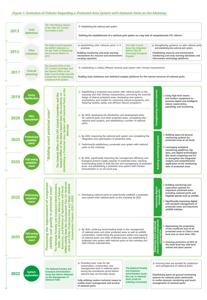
In recent years, the State Council has issued a series of policies for national parks to promote the establishment of a protected area system with national parks as the mainstay. These policies have set out requirements for the development of digital and smart protected areas or national parks at different stages and levels, creating a sound policy environment for the development of smart protected areas or national parks.
In 2019, the Guidelines on Establishing a Protected Area System with National Parks as the Mainstay was issued by the General Office of the CPC Central Committee and the General Office of the State Council. The Guidelines lists building of smart protected areas as an important task, and specifies the application scenarios and development directions for smart protected areas. Specifically, the document stipulates:
"Use high-tech means and modern equipment to enable digital and intelligent nature conservation, patrolling, and monitoring; build space-air-ground integrated monitoring systems for protected areas at all levels and of all types to conduct ecological environment monitoring, fully utilizing satellite remote sensing and monitoring sites for ground ecosystems, environments, meteorology, hydrology and water resources, soil and water conservation, and oceans; and leverage environmental monitoring platforms, big data, and cutting-edge technologies like cloud computing and IoT to strengthen the integrated analysis and comprehensive application of monitoring data of protected areas."
In 2022, China's National Forestry and Grassland Administration (NFGA), National Development and Reform Commission (NDRC), Ministry of Finance, Ministry of Natural Resources, and Ministry of Agriculture and Rural Affairs jointly issued the Development Plan for National Parks and Other Protected Areas and Major Wildlife Conservation Projects (2021–2035).
The plan specifies the objectives of establishing species monitoring and management systems and improving digital management levels for China's protected area development and wildlife protection agendas over the next 15 years. In addition, the Interim Measures on the Management of National Parks issued by the National Forestry and Grassland Administration states the need for national park administrations to make full use of modern technical means to improve the management and service efficacy, and enable smart management and services of national parks. China's Law on National Parks (Draft for Soliciting Comments) also published in 2022 states that:
"The State Council department in charge of forestry and grasslands should work with other relevant State Council departments to establish space-air-ground integrated monitoring systems, apply advanced technical means, reasonably distribute monitoring sites, and carry out comprehensive monitoring and assessments to achieve dynamic monitoring and smart management of national parks nationwide. National park administrations should monitor the natural resources, natural ecosystems, and specific protected species in national parks; conduct ecological risk assessments, provide early warnings, and analyze the impact of human activities; share monitoring data with relevant departments; and regularly issue monitoring and assessment reports."
New Requirements: A Scientific Approach to Designing and Managing Smart Protected Areas
A scientific approach to designing and managing protected areas is necessary to achieve the objectives defined for them. Designing a scientifically protected area includes identifying the right locations, and setting and managing different zones such as corridors and buffer zones. Scientific protected area management aims to maximize social and economic benefits while also maximizing ecological benefits. In particular, this includes the management of ecological goals (protecting species, communities, and ecosystem structures and functions), scientific research, administration, external publicity, and tourism.
To ensure the scientific design and management of protected areas, administrators should consider the following:
- Whether resources and protected species in the areas are comprehensively monitored and whether the threats they face are effectively mitigated;
- Whether diverse types of natural and cultural resources are effectively managed;
- Whether engagement with local communities is effective and whether co-management with local communities can achieve the goal of prioritizing dispute resolution; and
- Whether the impacts on local communities and local socio-economic development have been comprehensively assessed. Internally, administrators should evaluate whether the personnel, funds, equipment, and facilities required by protected areas and management organizations are all in place. Administrators must also regularly review completed management activities to monitor the achievement of objectives and the implementation of work plans and arrangements, and thus ensure management activities progress as planned.
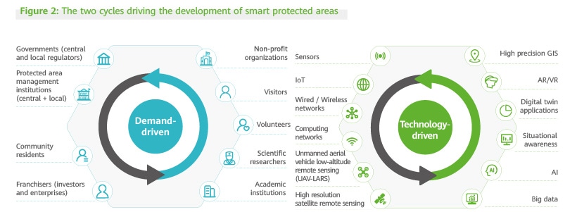
To sum up, the need for scientific design and management have presented a clear direction for smart protected areas: development based on the comprehensive acquisition of data. To create a virtuous circle of conservation management, administrators should, first, support scientific research and management with emerging technologies to implement conservation measures, create more value with conservation efforts, and mitigate threats to protected areas; second, seek necessary investments by assisting in the development of customized management plans; and third, achieve management goals through scientific management and set new objectives and activities to maximize the value of conservation efforts. This virtuous circle is a process of obtaining data while controlling and preventing threats through smart solutions in order to create more value with conservation efforts in protected areas.
New Driver: Rapid Technological Advances and Multi-level Stakeholder Requirements Make Going Smart Inevitable
Emerging technologies, such as cloud computing, IoT, big data, AI, and 5G, are developing rapidly worldwide and driving the rapid development and extensive application of smart devices, new sensors, and drones. Many cutting-edge technologies have been tested, and are being quickly applied to different fields, industries, and daily life. This has led to the digital transformation of many fields and numerous innovative management models and application scenarios. As solutions for smart parks, smart campuses, smart transportation, and smart cities become increasingly mature, and conditions for applying these technologies become more complete, emerging technologies will provide new solutions to help resolve the challenges in constructing and managing national parks and other protected areas.
According to the Overall Plan for Establishing a National Park System issued by the General Office of the CPC Central Committee and the General Office of the State Council in 2017, national parks should follow the principle of state-led multi-party management. A long-term whole-of-society approach for national park conservation and management involving the government, enterprises, social organizations, and the general public should be established, and new models need to be explored to enable social entities to participate in natural resource management and ecological protection. As the national park system pilot projects are gradually completed and the national park system is continuously improved, relevant stakeholders will assume more responsibilities in the development and management of a protected area system with national parks as the mainstay, and more stakeholders will be involved in the process. This will create new real-world needs and multi-level requirements. The quickly increasing needs of stakeholders are also accelerating the construction of smart protected areas, which will be a key area of focus for future development.
According to the Guidelines on Establishing a Protected Area System with National Parks as the Mainstay, we should establish an ecological environment monitoring system for protected areas such as national parks. We should formulate related technical standards, build space-air-ground integrated monitoring network systems for protected areas at all levels, and deploy digital technologies such as cloud computing and IoT. These technologies will help strengthen the integrated analysis and comprehensive application of protected area monitoring data; understand the composition, distribution, and dynamic changes to ecosystems in protected areas; proactively evaluate and give ecological risk warnings; and regularly release ecological environment monitoring and evaluation reports. We should also monitor human activities, such as infrastructure construction and mineral resource extraction, in protected areas.
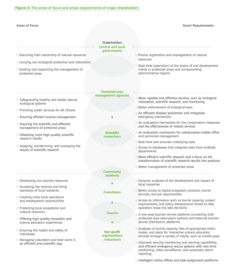
Key Challenges for the Development of Smart Protected Areas
The Development of Smart Protected Areas
The development of smart protected areas can be traced back to the development of nature reserves. The construction of smart protected areas has intensified over time, from initially promoting the digitalization and informatization of protected areas, to more recently developing a smart protected area system with national parks as the mainstay. Generally, the development of smart protected areas can be divided into three main phases.
The first phase is to build databases. Digitally manage basic geographic information, basic biological resources and materials, and key management archives of protected areas; mark the boundaries, functional zones, main protected species, vegetation, hydrographic features, major threats, and protection activities on a map; and use geographic information system (GIS) software to establish geospatial information systems. For example, the above materials have become mandatory attachments to national nature reserve plans (Technical Guidelines for the Overall Planning of Nature Reserves, 2011; and Construction Standards for Nature Reserves, 2018). Some of China's earlier nature reserve protection management projects, which were supported by the Global Environment Facility (GEF), also considered the digitalization of natural reserve materials and development of underlying ecological data maps as two of their key tasks.
For example, nature reserve management projects have been carried out to promote sustainable forestry development in nature reserves such as the Hubei Shennongjia National Nature Reserve and Sichuan Tangjiahe National Nature Reserve. The Guangxi nature reserve management project has developed underlying ecological data maps for nature reserves. Specific digitalization requirements have also been proposed for national scenic spots.
The second phase is to build information systems. As part of national informatization planning, the former National Forestry Administration strengthened the regulations on forestry informatization in the 11th, 12th, and 13th Five-Year Plans, as well as the policies issued in 2011, 2012, and 2013 , to gradually establish an efficient, convenient, stable, secure, connected, and comprehensive forestry informatization system. The aim is to promote informatization of the forestry system by promoting scientific forestry management, standardizing work processes, promoting transparent supervision, and providing convenient services. Nature reserves have also made efforts to promote informatization and build information systems and information management platforms based on monitoring data from different sources. For example, the Qinghai Lake National Nature Reserve has cooperated with the Chinese Academy of Sciences to establish a monitoring and scientific research data system. Nature reserves, such as the Changqing National Nature Reserve, Daqing Mountain National Nature Reserve, Changbai Mountain National Nature Reserve, and Wolong National Nature Reserve have also established information systems and platforms.
The third phase is to promote pilot projects of smart management. The 13th Five-Year Plan published in 2015 outlined the "Internet+" forestry development model. This smart development model focuses on the integration of new digital technologies, such as cloud computing, IoT, mobile Internet, and big data, into various forestry services to build new and innovative forestry development models. The wildlife conservation and nature reserve construction project plan published in 2021 specifies that one of the key objectives is to build space-air-ground integrated monitoring networks for national parks and nature reserves. Many nature reserves, such as the Wolong National Nature Reserve, Qinghai Lake National Nature Reserve, and Houhe National Nature Reserve, have piloted smart management techniques. The focus on the application of smart management techniques in pilot national parks has greatly promoted the development of smart national parks. Five national parks (Sanjiangyuan National Park, Giant Panda National Park, Northeast China Tiger and Leopard National Park, Hainan Tropical Rainforest National Park, and Wuyi Mountain National Park) have set informatization and smart management as priorities.
The Status Quo of Smart Protected Areas
In recent years, China has used smart methods to refine the management of protected areas. National parks have actively promoted digitalization and explored the application of smart methods. In particular, they have used innovative monitoring technologies and networks to enhance data collection. Big data and AI have also been used to monitor natural resources and supervise their use. In the future, protected area management institutions will use smart methods to keep track of the real-time status of protected areas and formulate more scientific and refined management plans to improve management efficiency, protection effectiveness and value, and the reliability and accuracy of scientific research. This will not only help the institutions tasked with managing protected areas enhance data insights, but it will also allow them to connect, analyze, and manage protected areas more effectively.
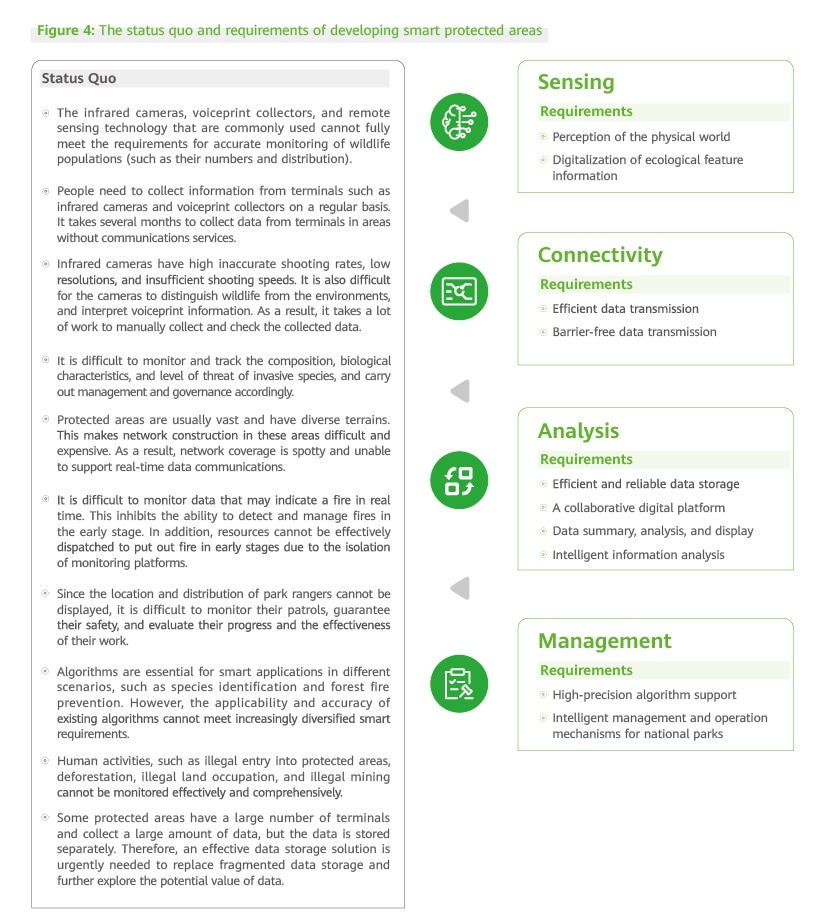
Key Challenges for the Development of Smart Protected Areas
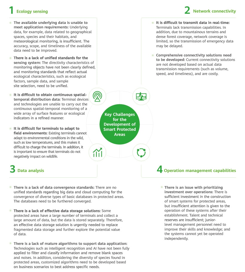
Intelligent equipment, facilities, and digital technologies have been actively deployed in the management and governance work of protected areas. However, unlike the smart development of mature settlements, the smart development of protected areas has encountered various challenges in basic data acquisition, standard system construction, network transmission, AI application analysis, and other aspects. In addition, each protected area has different geographical environments, resources, and protected species. As a result, the technologies and methods required also vary. All of these factors have made it more challenging to pilot and implement smart technologies, methods, and facilities for the development and management of protected areas.
- In February 2009, the National Forestry Administration officially issued the Outline of National Forestry Information System Construction (2008–2020) and the Technical Guide for National Forestry Information System Construction (2008–2020).


A Blueprint for Building Smart Protected Areas
Key Scenarios of Smart Protected Areas
According to the Guidelines on Establishing a Protected Area System with National Parks as the Mainstay, cloud computing, IoT, and other digital means will be important tools for strengthening the integrated analysis and comprehensive application of monitoring data in protected areas, developing a strong understanding of the composition, distribution, and dynamic changes to ecosystems in protected areas, and assessing and warning of ecological risks.
The National Protected Area Development Plan (2021–2035) proposes to build a protected area supervision and management platform. Based on the level of protected areas, we will build space-air-ground integrated monitoring and supervision platforms at the national, provincial, and protected-area levels by using technologies such as 3S3 and digital technologies, networks, AI, visualization, cloud computing, IoT, and big data, as well as emergency rescue, command, and dispatch systems. The real-time monitoring data and images related to wild animals, plants, and their habitats, as well as other information obtained by ecological monitoring stations in protected areas, will be transmitted to national and provincial supervision platforms and reviewed in real time, ensuring that there is a consistent set of data for protected areas across different supervision platforms. The aim is to gradually develop a digital, intelligent, and Internet-based protection model for protected areas that allows wild animals and plants to be effectively monitored and human activities to be managed.
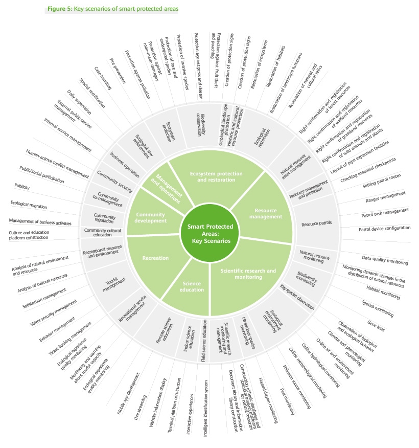
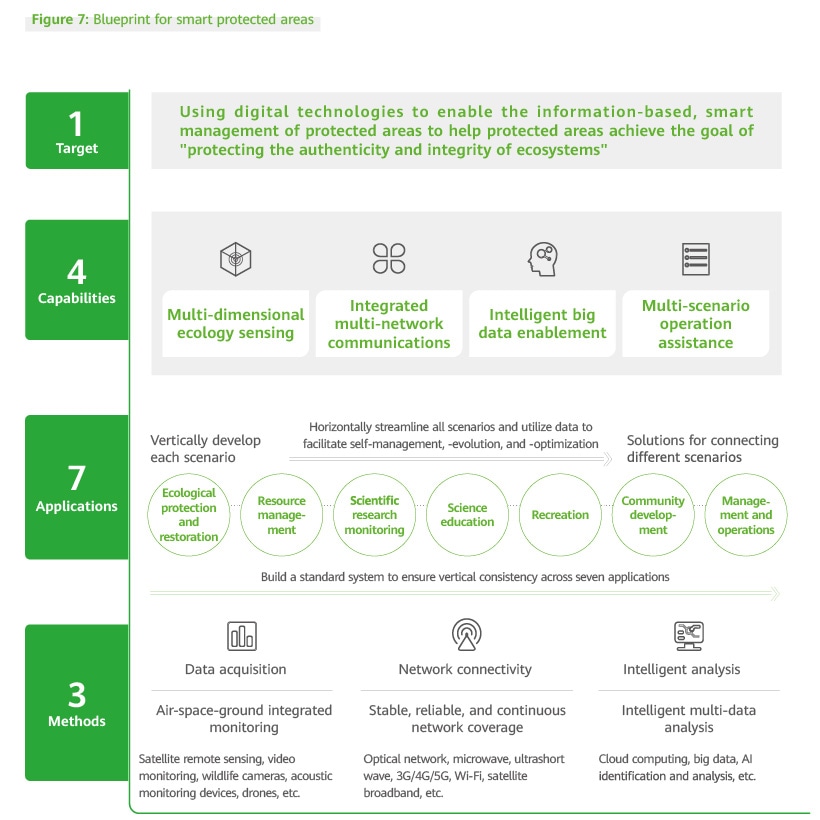
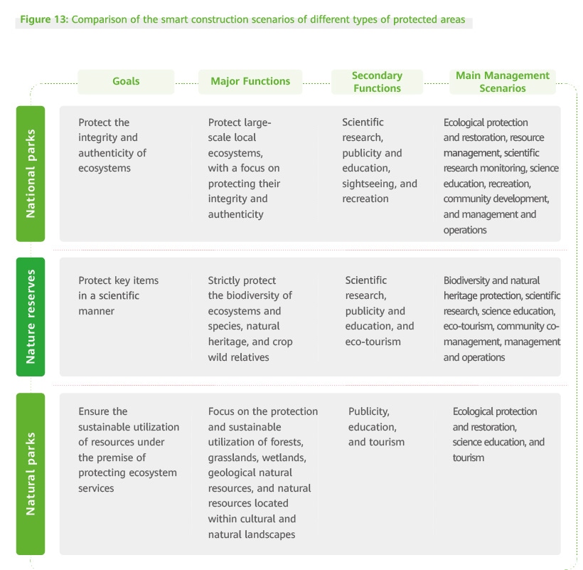
The primary purpose of national parks is to protect the authenticity and integrity of important natural ecological systems. National parks also play other roles, such as facilitating scientific research and providing education and recreation services. The Technical Specifications for the National Park Master Plan (LY/T 3188-2020) puts forward management plans and specific development goals in terms of ecological protection and restoration, resource management, scientific research monitoring, science education, recreation, community development, and national park management and operations. Technologies such as cloud computing, IoT, mobile Internet, big data, and AI can be applied during the creation and management of national parks. The application of various smart technologies, support systems, and standards will promote the intelligent and refined construction and management of national parks, and this will help us achieve conservation objectives in national parks.
The development of smart protected areas should be closely aligned with related plans and objectives, and provide managers and other related parties with the best solutions. We have identified and outlined the scenarios in which digital and smart technologies can be applied in protected areas now and in the future based on the application of information-based and digital technologies in protected areas, the available functions of terminal devices, digital formats, intelligent management and control, and general services of smart technologies and terminal functions in the construction, management, and operations of future protected areas.
- 3S refers to a combination of a geographic information system (GIS), remote sensing (RS), and global positioning system (GPS).
Characteristics of Smart Protected Areas
Smart protected areas are positioned to preserve the authenticity and integrity of key natural ecosystems in protected areas based upon technology and actual needs. Digital technology solutions are introduced in response to key challenges, stakeholder needs, and the application potential of digital technologies. The key characteristics of future smart protected areas are as follows:
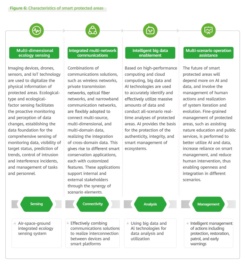
Future smart protected areas will use integrated digital technologies, comprehensive sensing, and ubiquitous connectivity to connect people, nature, and devices, and implement end-to-end computing. Digital platforms will eliminate physical and logical data silos, streamline cross-scenario collaboration, and enable all-scenario intelligence in protected areas. Integrated platforms for top-level design will give both application systems in different scenarios and devices stronger analysis and interaction capabilities, allowing them to assist in the smart management of protected areas.
In conclusion, the application scenarios of emerging technologies in protected areas are both complex and diverse, while the key needs of stakeholders are diversified and differentiated. A blueprint framework for smart protected areas can comprehensively show the needs and development directions of smart protected areas. Such a blueprint can also inspire the creation of smart protected areas that all of society cares about and supports.
Development Stages of Smart Protected Areas
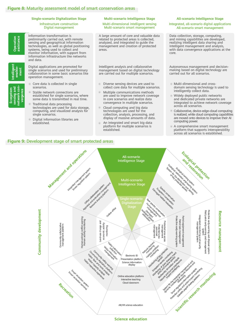
Smart protected areas cannot be created overnight and the industry has yet to develop unified evaluation standards for them. We have developed a smart protected area maturity model based on the smart protected area blueprint and the required capabilities for creating smart protected areas. This maturity model can be used to evaluate and compare smart protected area maturity at different stages and set goals for each stage.


Smart Protected Areas Solution
Smart Protected Areas Solution Architecture
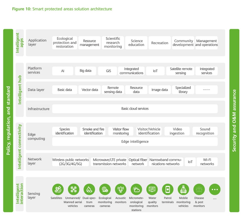
The smart protected areas solution leverages information and communications technologies (ICT) such as 4G/5G, ad hoc networking, cloud computing, Internet of Things (IoT), mobile Internet, and big data. The solution supports applications like ecological protection and restoration, resource management, scientific research monitoring, science education, recreation, community development, and integrated management.
The solution architecture consists of seven layers and two systems. The seven layers are the sensing, network, edge computing, infrastructure, data, platform, and application layers. The two systems are the policy, regulation, and standards system and the security and O&M assurance system. The layers and systems are closely linked and support each other, ensuring the information system is trustworthy, controllable, and manageable.
Sensing Layer
Various devices are used to collect wildlife information, obtain data about various ecological factors like climate and hydrology, issue early disaster warnings, and accurately monitor human activities in real time in protected areas. These include smart monitoring devices; patrol equipment; sensors, such as video monitoring, acoustic monitoring, meteorological and water quality monitoring; satellites; unmanned/manned aerial vehicles; patrol terminals; and mobile monitoring vehicles, Alongside the use of smart terminals for display, these technologies enable comprehensive, in-depth sensing in protected areas.
- Forest fire monitoring with satellite remote sensing: The remote-sensing forest fire monitoring service is based on theories from across a number of fields like geography, atmospheric science, forestry, and fire science, as well as technologies like satellite remote sensing (geostationary satellites and polar orbiting satellites), geographic information systems, digital elevation models, global positioning systems, spatial decision support systems, and computer networks. This service goes beyond the traditional forest fire monitoring and response model, providing support for forest fire prevention information management, forest fire monitoring, fire risk forecasts, auxiliary management of fire-response solutions, and forest fire loss assessments.
- Biodiversity monitoring: To meet scientific distribution and monitoring requirements, monitoring spots can be established in wildlife habitats and areas with regular wildlife activity. For example, by installing infrared cameras, triggered, or ultrashort wave transmission ecological monitoring cameras, and HD dual-spectral zoom cameras with laser night vision functions, species' movements can be clearly tracked day and night. Additionally, instruments like all-weather wildlife acoustic monitors are employed to record animal sounds and then remotely transmit them for acoustic spectrum analysis. Furthermore, drone cameras are used to monitor moving targets in specific areas in real time to collect attribute data such as wildlife populations, wildlife habitats, types of wild plant species, and wildlife distribution, ensuring the dynamics of species distribution can be effectively tracked.
Ecological-element and ecosystem monitoring: Environmental, biological, and ecosystem analysis models can be generated through the collection of data related to biological elements and growth, as well as data collected at meteorological, air, hydrological, and soil monitoring stations. With the use of environmental monitoring technology based on satellites and drones, and the application of biodiversity and ecosystem monitoring technologies in protected areas, it is possible to conduct resource and environmental monitoring and surveys, the monitoring of typical species and ecosystems, and the collection and digitalization of basic data on biodiversity, ecosystems, and environments. This makes it easier to keep track of current resource conditions and understand the development direction and constraints of protected areas, while also offering a basis for evaluating ecological benefits and the effectiveness of conservation efforts.
Today, China uses TanSat, a scientific experiment satellite dedicated to monitoring the amount of carbon dioxide in Earth's atmosphere alongside other remote sensing data from multiple sources. The satellite monitors and analyzes the spatial and temporal distribution of carbon sources and sinks worldwide and in key regions, providing useful scientific data for evaluating the carbon sequestration capacity of ecosystems.
Network Layer
Network transmissions are like the pulse of smart protected areas. Depending on an area’s terrain, forest coverage, and existing public network coverage, it is advisable to flexibly adopt combinations of communications solutions, for example, wireless public networks, private transmission networks, optical fiber networks, narrowband communication networks, IoT, and Wi-Fi. This aims to enable networks as a whole to overcome the limitations of obstacles and rugged terrain, and achieve efficient communications at minimal cost.
Integrated Network Solutions
Unlike in urban areas, full network coverage is often impossible to achieve in protected areas due to limitations created by geography, climate, equipment power supply conditions, laws and regulations on ecological protection in some core protected areas, and budgets. Therefore, it is necessary to strike a balance between various communications technologies, while existing network resources must be employed to adapt network deployment plans to the conditions of protected areas.
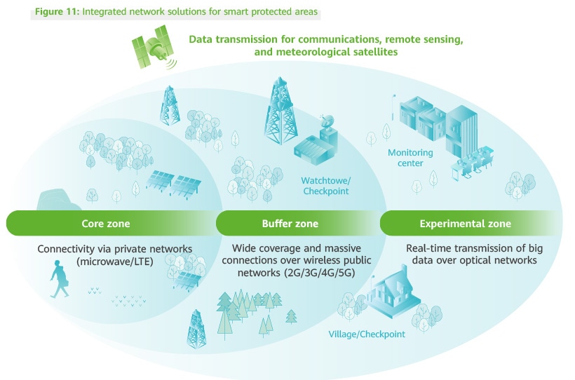
Wireless public networks
2G and 3G refer to the second and third generation of wireless communications technologies, respectively. 2G centers on digital voice transmission technology, whereas 3G can transmit both voice and data.
4G and 5G refer to the fourth and fifth generation of wireless communications technologies, which feature high transmission rates, low latency, and high access performance. 4G and 5G are the main wireless communications technologies currently used in protected areas. Compared with 4G, 5G offers higher transmission rates, lower latency, and more device connections per square meter (1 million connections with 5G vs 100,000 connections with 4G), though at higher construction cost. Therefore, it is important to adopt the right technologies based on local characteristics and construction budgets.
| Performance Indicator | 4G | 5G |
|---|---|---|
| Average Rate | 25Mbit/s | 100Mbit/s |
| Peak Rate | 300Mbit/s | 20Gbit/s |
| Latency | 10~50ms | 1ms |
| Tolerated User Moving Speed | <350km/h | >500km/h |
5G and 4G performance indicators
Typical advantages: High transmission rates, low latency, and high access performance.
Typical limitations: Protected areas are typically located far from residential and commercial areas, so the number of wireless base stations is limited, and other technologies are needed to supplement them.
Microwave/LTE private transmission networks
In protected areas that cannot be covered by operators' public networks, ad hoc microwave/long-term evolution (LTE) networking can be used for data backhaul and wireless communications.
Microwave private transmission networks
The microwave solution is a wireless communications method that uses microwave as a medium, with wavelengths ranging from 0.1 mm to 1 m. This solution is used in protected areas, typically for data transmission to and from monitoring sites.
Typical advantages: Large capacity, stable transmission performance, low cost, and strong disaster resilience make these networks able to meet communications requirements of various applications, such as lightning detection, automatic meteorological forecasts, data processing, and computer networking. These capabilities enhance forest fire prevention, communication commands, and production dispatching capabilities. The adoption of satellite communications technology and the use of satellites as relay stations for transmitting microwave signals solve the problems of blocked real-time data transmission caused by difficulties in laying cables in remote mountainous areas, lack of signals in the field, and partial signal blocking in forests.
Typical limitations: Point-to-point microwave communications can be easily blocked and certain line of sight (LOS) requirements need to be met.
LTE private transmission networks
LTE is an evolution of 3G technology that enhances 3G's air interface technology. LTE delivers a peak downlink rate of 100 Mbit/s, an uplink rate of 50 Mbit/s, and 20 MHz spectrum bandwidth. LTE technology has two main modes: time division duplex (TDD) and frequency division duplex (FDD), and each has unique characteristics.
FDD-LTE is widely used worldwide, while TD-LTE is more common in China.
Typical applications in protected areas include video transmission in surveillance sites, device communications, and the real-time transmission of monitoring data from wildlife cameras. In dense forests within protected areas in southwest and southern China, low-frequency bands like LTE 400 MHz and 700 MHz can be used for communications to improve both penetration and coverage.
Optical fiber networks
Optical fiber networks refer to WANs, MANs, newly built large-scale LANs, and private networks between field monitoring sites and a command center that use optical fiber as the main transmission medium and equipment such as optical line terminations (OLTs) and optical network units (ONUs).
Typical advantages: Optical fiber networks support large-capacity and high-speed communications, and are characterized by low loss and large transmission capacity. They are lightweight, compact, and resistant to electromagnetic interference. In ideal situations, optical fiber networks can deliver large-scope gigabit ultra-broadband access in protected areas. They can be used in transmission backbones for protected areas where network construction is feasible.
Typical limitations: High cost and difficulties in laying optical fiber in areas with steep mountains.
Satellite communications
Satellite communications involve communications between two or more wireless communications sites on the earth that use artificial earth satellites as relays. Wireless communications sites come in many different forms, including terrestrial, aerial, surface, and underwater. These can be collectively referred to as earth stations. Earth stations may be fixed, maneuverable, or mobile. A typical application in protected areas is emergency rescue.
Typical advantages: Wide coverage, less impacted by terrain, large communications capacity, and good channel conditions.
Typical limitations:High signal transmission latency due to satellite orbits high above the ground, signal attenuation in rain and snow, and high cost in terms of network construction and use.
Ultrashort wave
Ultrashort wave communications refer to communications at the frequency of 30–300 MHz, with a wavelength between 1 and 10 meters. Typical applications in protected areas include data backhaul for low-power monitoring devices.
Typical advantages: Wide coverage, simple device networking, strong invulnerability, and low cost.
Typical limitations: Low data transmission rates and high network noise.
Internet of Things (IoT)
IoT collects, in real time, the information of objects or processes that require monitoring, connection, and interaction through the use of various devices and technologies. These include information sensors, radio frequency (RF) identification technologies, global positioning systems, infrared sensors, and laser scanners. The data collected can relate to, for example, sound, light, heat, electricity, mechanics, chemistry, biology, and location.
A typical application scenario is ecology sensing in protected areas. Sensors and IoT gateways can be used in combination to monitor the lighting, temperature, humidity, soil moisture, tree diameter growth, and water quality in protected areas in real time.
Typical advantages: Low power consumption, wide coverage, and low cost.
Typical limitations: Short transmission distance, small amounts of data transmitted, and low transmission rate.
Wi-Fi Networks
Wi-Fi is an industry standard (IEEE 802.11) defined by the Institute of Electrical and Electronics Engineers (IEEE) for wireless network communications. Together, Wi-Fi wireless networks and 4G/5G mobile networks constitute the communications networks of tourist zones in protected areas.
Typical application scenarios in protected areas include sightseeing, recreation, and science education. For example, in visitor centers and science education venues, free Wi-Fi networks are provided for tourists. In some scenic spots, networks can be upgraded to Wi-Fi 6 to support access by large numbers of mobile terminals and provide higher network bandwidth, delivering a faster and more stable network experience.
Typical advantages: High bandwidth and low power consumption.
Typical limitations: Signals susceptible to interference and short coverage distance.
Edge Computing
Edge computing integrates network, computing, and storage capabilities at the edge of a network. Edge computing is located close to objects or data sources and provides intelligent interconnection services nearby. Edge computing also acts as a supplement to and optimization of cloud computing. The combination of edge computing and cloud computing platforms is an ideal computing solution for the protection of natural resources.
Edge Computing
Edge computing mainly applies to the real-time processing and analysis of local and short-term data. In areas that suffer from poor network conditions, time-lag occurs when data is transmitted to the back-end platform for processing. Ideally, front-end devices should support processing capabilities.
Application scenario 1
Checkpoint monitoring devices and ecology monitoring devices in some remote protected areas need to process a large number of videos in real time every day. To support this, algorithm applications, such as those for people/vehicle identification, species identification, and sound identification, can be deployed nearby. This eliminates the need to transmit video streams back to the cloud for processing, thus improving processing efficiency and saving bandwidth resources.
Application scenario 2
In forest protection scenarios, fire warnings must be issued in real time, and ecology monitoring cameras must possess certain processing capabilities. In such scenarios, edge terminals can perform fast computing locally and return results to the front end in real time, supporting local service implementation, intelligent processing, and management execution. These operations are no longer restricted by poor outdoor network transmission signals.
Infrastructure
Basic cloud services are used to deliver big data hosting services over networks based on cloud computing technologies. The cloud computing platform features both on-demand use and dynamic scaling. Virtual resources can be employed to provide computing, storage, and information resource services. Such resources are supported by the virtual cloud infrastructure platform.
Cloud Computing Technology
Cloud computing incorporates numerous functions such as massive information management, transfer, and queries. It also supports big data analytics, which is suitable for processing global, non-real-time, and long-term data. It has the ability to integrate different application systems and connect different data sources to realize application and data integration and provide various data services. It is also suitable for building integrated management platforms for smart protected areas. During the construction of smart protected areas, cloud computing can help the corresponding administrators address management requirements and improve the management of the protected areas by collecting, analyzing, and processing massive amounts of data. Tourists and community members can also obtain information about protected areas through the cloud computing platform, such as the best times for sightseeing, recreation facilities available in certain areas, and commentary services provided at certain exhibition sites.
Data Layer
Based on unified data standards, all multi-source information (e.g., information of space, time, audio, video, and other forms of multi-media) related to factors and activities that affect the protection of forests, such as wildlife, wildfires, pests, and patrols, is integrated into a comprehensive map. This facilitates the creation of a geographical spatiotemporal database of protected areas based on related data. Based on this map, data cleaning, processing, aggregation, governance, and application services are implemented, realizing information sharing, agile service development, and strategic innovation on a unified service platform.
Platform Layer
This layer includes AI, big data, GIS, integrated communications, IoT, satellite remote sensing, and integrated services. It provides an intelligent, collaborative, inclusive, and open foundation for the cloud platform that powers the application systems. This layer handles information processing, massive data processing, business process specifications, data table model analysis, intelligent management, and predictive analysis for the entire system. It also provides platform-based support services and agile development plug-ins for natural-resource monitoring, emergency command, and intelligent diagnosis.
AI Platforms
Computing power, algorithms, and data are the three core elements of AI. The AI platform is the core engine of the smart protected area solution. It is used to develop platform services that integrate a number of capabilities such as data labeling, model training, model release, and inference deployment. The system can then quickly deliver intelligent services in a closed-loop.
The AI platform can be flexibly deployed locally or on the cloud. Through local data collection, local or on-cloud algorithm training, and local algorithm deployment, the AI platform ensures the security of data, algorithms, and services. Based on the AI platform, it is possible to quickly build an AI algorithm model library with regional characteristics, and implement intelligent algorithms for the purpose of rare flora and fauna identification, intelligent wildfire warnings, and geological disaster risk warnings.
Big Data
Big data refers to a massive amount of valuable data, the scale of which is too large for mainstream tools and software to process and analyze and convert into information that is valuable to departments or enterprises. Big data is distinguished by four Vs: Volume, with terabytes or even petabytes of data; Variety, including structured, semi-structured, and unstructured data; Velocity, meaning faster generation speed; and Value, the combination of the first three features.
With the evolution and application of information technologies such as IoT, 3S (GIS, RS, and GPS), and mobile Internet, the sources and types of data generated in protected areas are increasing. In addition to traditional data sources in protected areas, such as remote sensing, GIS, and digital collection terminals, new sources like sensors, multimedia, space, and geographical-location services have all emerged. In the context of big data, the spatial distribution of data in protected areas is wider, the time scale is more variable, the validity period is longer, the data volume is larger, and the processing speed is faster. Exponential data volume growth will become the new normal.
The key technologies of big data include parallel computing, stream computing, remote sensing, visualization, data mining, and distributed technologies. According to the data generation mode and structural characteristics, data analysis is divided into six key technical fields: structured data analysis, IoT sensing data analysis, web analysis, multimedia analysis, social network analysis, and mobile analysis. Big data technologies can be preferentially applied to improve the accurate decision-making capabilities of protected areas and help integrate and share data resources.
Application Layer
Enabling seven scenarios:
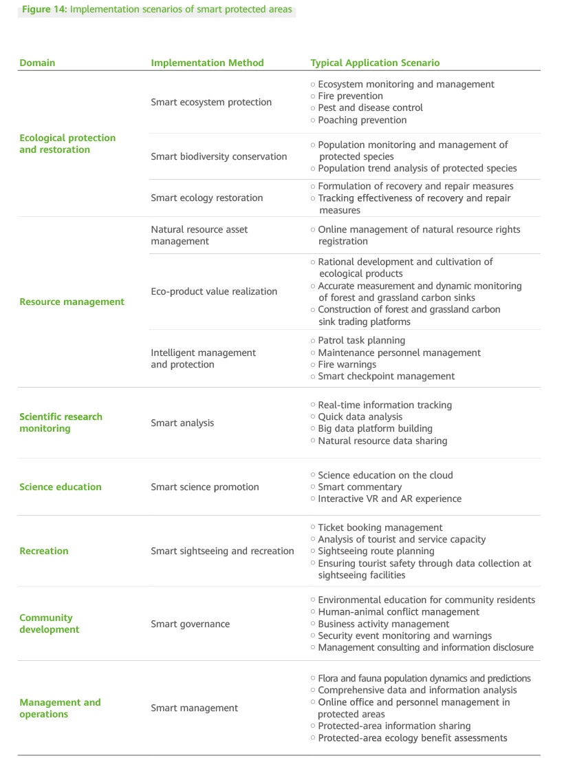
Based on the data at the platform layer, various smart applications should be developed to support the seven scenarios of protected areas. These are ecological protection and restoration, resource management, scientific research monitoring, science education, recreation, community development, and management and operations. In addition, to achieve the objectives of each scenario, stakeholders in the protected area, including scientific researchers, conservationists, educators, community residents, and tourists, can connect to the resources of the protected area through smart applications to help optimize the experience in each scenario.
Intelligent management methods:
Rebuild management methods, optimize management processes, and enable management innovation by employing the smart applications provided by the underlying big data system, combined with the visualized data screens of the protected area management office, and the medium and small screens of managers. This will help create better protected areas.
Construction of Smart Protected Areas
As technologies and infrastructure become increasingly mature, intelligent applications can be gradually implemented across various segmented scenarios of protected areas. At the same time, applications will become increasingly abundant, gradually covering all aspects of protected areas. This section uses the examples of the main application scenarios relating to wildfire warnings, species monitoring, patrol management, and smart science education to analyze the implementation of smart protected areas.
Within protected areas, national parks, nature reserves, and natural parks all have different positioning, and they also differ in terms of the core application scenarios for their intelligent construction. National parks focus on the systematic and comprehensive conservation of ecosystem integrity and authenticity to protect flagship species and provide ecosystem services. Nature reserves aim to protect key items, which serve as the basis for scientific research, publicity and education, and community co-management. Natural parks focus on sustainable utilization, with core application scenarios that differ from the first two.
Wildfire Monitoring and Warning System
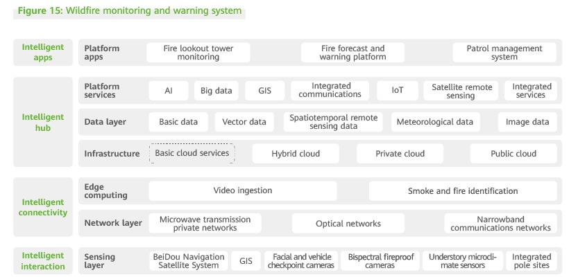
Feasible wildfire prevention systems should be built according to actual forest coverage in protected areas. Through interconnected and interoperable data, it is possible to realize integrated scheduling, interconnected coordination, and unified command that covers the entire process, from collection at the front end to remote monitoring at the back end.
Comprehensive Sensing
Front-end monitoring devices and collection points are used to collect multi-dimensional data onsite in real time. Surveillance site data is obtained through bispectral, fireproof cameras and low-illumination fog penetration cameras. Front-end cameras and pan-tilt-zoom (PTZ) devices are operated and controlled to obtain real-time angle data. The collected data and the GIS system are used together to precisely locate the origins of fires. Meteorological sensors are deployed at the front end to obtain wind speed, wind direction, temperature, and humidity data from the monitoring point in real time.
Data Aggregation
Front-end surveillance devices transmit collected images to the cloud or surveillance center through wired or wireless transmission systems. Cameras with edge computing capabilities perform initial identification. Then, images and videos are transmitted to the cloud for secondary identification, improving the accuracy of fire identification. The construction of private communications networks typically means high operating costs from base stations and optical fibers. Therefore, microwave transmission is recommended. Prefecture-level forest and grassland systems face key challenges such as a lack of unified and standardized data formats. This means data cannot be aggregated to the provincial-level system. To solve this problem, a data platform should be constructed to centrally manage both applications and data. Forest and grassland data can be managed through data warehouses and data lakes on this platform, allowing the data to be mined, which unlocks greater value.
Intelligent Analysis
Real-time multi-shot images are obtained through the transmission system, after which related data is summarized on the cloud platform. The wildfire identification algorithm, which is based on computer vision technology, ensures fires are accurately identified. Furthermore, continuous training is performed on the intelligent platform to constantly improve algorithm accuracy. Big data and cloud computing should be used to analyze and develop reasonable handling and scheduling policies to provide support for management.
Auxiliary Management
Through front-end collection, transmission, and intelligent AI recognition, high-accuracy images and videos are sent to the surveillance center in real time to more effectively monitor fires, allowing for remote commanding and dispatching of the command center. At the same time, the fire monitoring and warning system can be efficiently linked with the field patrol system. This allows the monitoring center to determine the appropriate response, and then send the decision to rangers to go where needed.
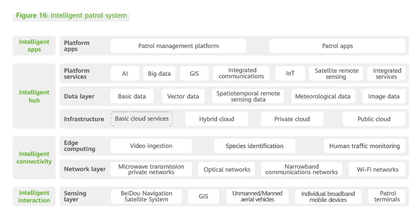
Intelligent Patrol System
Field patrols are the most important method for managing and protecting national parks and nature reserves. The patrol work carried out in natural parks primarily focuses on the management of ecotourism areas. Field patrols are typically characterized by mobility, as well as a sense of emergency and danger. It is necessary to build a patrol management system to handle personnel management and natural resource monitoring and facilitate the closed-loop management of personnel, route setting, task management, data collection, and on-site dispatch.
Comprehensive Sensing
Smart terminals that possess positioning and communication functions, such as intelligent patrol terminals equipped with the BeiDou navigation system, can accurately track and locate patrol personnel in real time to better understand their operations. By incorporating positioning and voice entry technologies, the entire resource investigation process is digitalized, including field observations, questionnaires, entity drawing, topographic profile drawing, photo taking, and investigation route collection. Such information provides field resource investigation workers with fast, accurate, and convenient data support. At the same time, the three links – investigation data preparation, field data collection, and internal data collation – are seamlessly connected.
Data Aggregation
A cloud-based patrol management system is provided to transform existing patrol work from single-format data management to unified-format digital management. Data, such as personnel routes, collected data/images, and personnel records is aggregated, and cloud big data analysis and processing capabilities, are employed to explore in-depth data value. In addition, high-speed networks are employed to improve the management process, and related results are reported to the management department in a timely manner, thus improving incident resolution efficiency.
Intelligent Analysis and Auxiliary Management
The command center accurately locates patrol locations and patrol routes within its managed areas through terminals, and implements the real-time monitoring and management of patrol personnel. Furthermore, the command center can monitor onsite images and HD videos in real time through a network to realize remote monitoring and management. This supports the quick and effective prevention of all kinds of actions that may threaten environments and species.
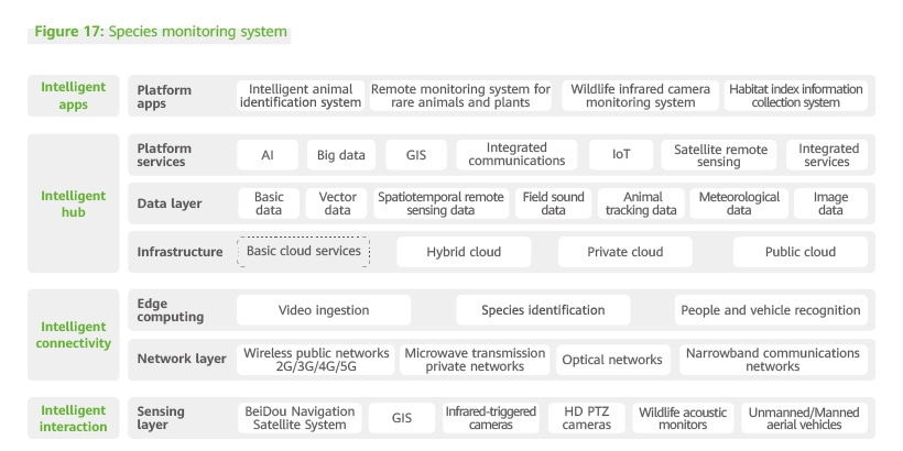
Species Monitoring System
Species conservation in national parks and nature reserves is crucial. National parks and nature reserves with wildlife and healthy ecosystems are rich in biodiversity, and often contain a large number of rare species and require a high level of conservation. It is necessary to fully utilize intelligent technologies to track individual and group activities, continuously monitor habitat changes, analyze population distribution and other changes related to key species, and remotely monitor illegal activities that disturb animals. This will ensure powerful technical support for the protection and management of wildlife and habitats.
Comprehensive Sensing
Sensing is performed using GPS, GIS, and modern communications technologies. Infrared-triggered cameras or infrared cameras using ultra-short-wave transmission are set up at key locations to automatically take photos of different species. HD PTZ cameras and video recorders are used for remote observation and to automatically record animals and plants. In areas with frequent wildlife activity, cameras with zoom lenses and laser night vision can support intelligent movement tracking, enabling clear tracking of wildlife day and night. Drone-based cameras are used to monitor moving targets in real time to collect data such as wildlife populations, habitats, species, and distribution, allowing observers to obtain a thorough understanding of the distribution dynamics of wildlife. All-weather animal acoustic monitors and other instruments are used to record the sounds of different animals at specific locations to realize long-distance transmission and remote acoustic spectrum analysis of wildlife sounds.
Data Integration
Data collected by devices such as infrared-triggered cameras is transmitted to the nearest edge computing node through wireless public networks, microwave communications private networks, optical fiber networks, and narrowband communications networks. AI algorithms are used for online real-time data analysis to quickly and intelligently identify and classify species. The data is automatically processed, classified, and stored in a database. In addition, the data is shared across departments through the cloud, which optimizes the use and management of the species data.
Smart Analysis and Management Support
GIS information and species information enable species data visualization, the dynamic updating of attribute data, positioning queries, management support, and data sharing and application. The protection system for key protected species supports big data analysis of the biological, ecological, and behavioral characteristics of key protected species or specific populations. The system helps predict the evolutionary and development trends of populations, and monitor and prevent interference. It facilitates planning adjustments, public awareness of science, scientific research, and biological corridor development. It also provides a management reference in the form of intelligent comprehensive analysis reports.
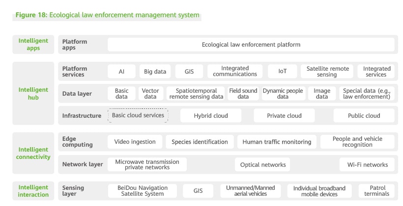
Ecological Law Enforcement Management System
Ecological law enforcement is key to the management of national parks, nature reserves, and natural parks. Inspecting ecosystems and understanding how to manage natural environments are prerequisites to forming a protection and law enforcement platform featuring smooth communication, rapid response to received information, and efficient operations. This system for maintaining the ecological security of protected areas is critical to preventing illegal activities such as natural resource theft and environmental destruction. It detects behaviors such as illegal harvesting, mining, herding, over-grazing, and poaching.
Comprehensive Sensing
Front-end monitoring devices support the monitoring of protected grasslands, forests, wetlands, water sources, glaciers, and wildlife. Satellite images are used to monitor ecological red lines, illegal construction, and resource changes. In addition, based on historical data such as case investigations, the BeiDou Navigation Satellite System and intelligent law enforcement patrol terminals are used for vertical inspection in areas with many previous cases. In this way, we can accurately track the locations and actions of law enforcers. This also enables the digital management of photos, routes, and other information during patrols.
Data Integration
Wireless public networks, microwave communications networks, and Wi-Fi networks are used to transmit data. AI algorithms are used to perform online real-time analysis to identify illegal activities such as logging and poaching in the core protected areas of national parks. The data is automatically processed, classified, and stored in a database. Moreover, the data can be shared through the cloud among different departments, such as those for environmental protection, natural resources, forests and grasslands, water conservation, and agriculture and rural areas.
Smart Analysis and Management Support
Managers can use the ecological law enforcement platform for command and dispatch, and to view on-site images and HD videos in real time when networks allow. This helps them perform remote monitoring and management, support patrols, and quickly and effectively stop violations related to environmental destruction.
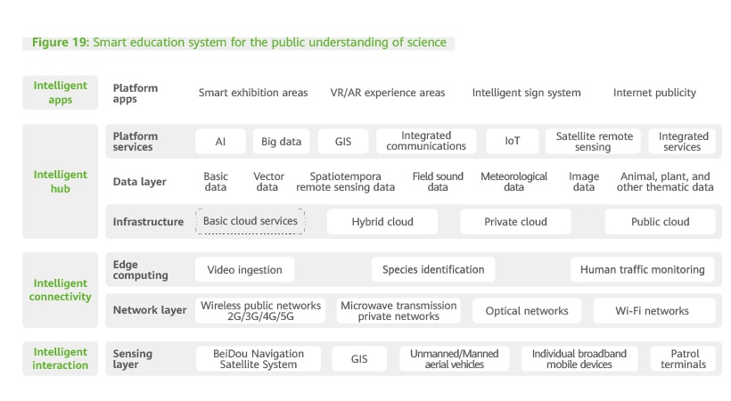
Smart Education System to Improve Public Awareness of Science
National parks, nature reserves, and natural parks play a key role in raising public awareness of science. The smart education system creates an immersive experience and supports scientific research and education activities. Including both the fruits of scientific research and a wide array of resources, the system enables both ecological protection and social development.
HD cameras and other devices are used to collect images for the system, which connects with other scenario-based platforms for consistent data sharing and presentation. Scientific research institutions, tourists, and other relevant parties can log in to the scenario-based platforms through websites and IP addresses, or learn about plant diversity and wildlife activities in protected areas through mobile apps, WeChat Official Accounts, and new media platforms.
Protected areas can adopt the intelligent sign system, and scenic spot description boards can intelligently identify the passing of tourists through sites. Tourists can use headsets or their mobile phones to listen to the descriptions of scenic spots. Educational exhibition halls offer new ways for people to experience and interact with virtual protected areas. They combine sound, light, images, animations, digital audio and video, holographic projection, and VR with physical scenarios, pictures, and scene simulations. Visitors can receive an immersive educational experience of nature through VR glasses or AR terminals.
Smart Protected Area Case Studies
Case Studies: Construction of Smart National Parks and Former Pilot National Parks
In 2021, 10 pilot projects in national parks in China reached basic completion. The first batch of national parks were established, including Sanjiangyuan National Park, Giant Panda National Park, Northeast China Tiger and Leopard National Park, Hainan Tropical Rainforest National Park, and Wuyi Mountain National Park. All national parks and the former pilot national parks prioritized ecological protection. They integrated different types and levels of projected areas, and implemented unified management, overall protection, and systematic restoration based on their unique natural resources and other practical factors. They also developed measures for ecological protection and restoration, resource management, scientific research monitoring, science education, recreation, community development, and management and operations. They defined key development directions and achieved remarkable results.
By June 2021, these national parks had all started digital and smart construction and management based on their unique high-value resources, key protection domains, and digital foundation. The 10 national parks have made remarkable progress and showcased their innovations in a few major application scenarios.
Ecological protection and restoration
In recent years, all national parks and former pilot national parks have started building digital platforms for space governance. For example, they have used infrared cameras for species identification and set up electronic fences and real-time monitoring equipment at the boundaries of core protected areas, realizing conservation, control, and transformation in ecological civilization construction. For example, the Qianjiangyuan Pilot National Forest Park conducted big data analysis on the main areas, activity times, and activity frequency of rare wildlife, generating an activity heat map. In addition, the area has established an automated service system for survey voucher management, appraisal, and information on natural resources.
Resource management
National parks and former pilot national parks have gradually built space-air-ground integrated monitoring and management networks, furthered biodiversity background surveys, strengthened special surveys and the assessment of rare and endangered species, and built a multi-dimensional information system for diversity data to gradually achieve digital management. The smart management platform of Wuyi Mountain National Park is one such example. By using a wide range of intelligent technologies, as well as drones, infrared cameras, patrol recorders, and other equipment, they have carried out grid-based patrols, realized comprehensive, all-weather, space-air-ground monitoring and management, and enhanced the protection and management of ecological resources. The Qilian Mountain Pilot National Park in Qinghai has built an intelligent management and protection system. The system can be accessed through desktop and mobile apps, and is constructed at the device, edge, and cloud level. Authority is delegated to management and protection stations to achieve rapid service provision. The project uses the positioning service of the BeiDou Navigation Satellite System for survey and patrols of natural resources such as forests, wetlands, grasslands, animals and plants, realizing comprehensive monitoring of rangers during patrol. This allows the park to track the real-time status of resource patrols, the work of rangers, and events occurring during patrols so that incidents can be promptly handled. The system provides support for the safety, task dispatch, and online monitoring of rangers, ensures resource safety, and improves patrol monitoring.
Scientific research monitoring
To better protect biodiversity, modern scientific and technological monitoring systems have been constructed for national parks, former pilot national parks, and nature reserves. These systems consist of digital cameras, drones, infrared cameras, and other modern equipment, enabling more timely and advanced scientific research monitoring. For example, in Wuyi Mountain National Park, the comprehensive monitoring system for biological resources and habitat elements can display information such as resource monitoring, patrols and law enforcement, and forest coverage on one map.
Education and recreation
National parks and former national park system pilots are using diverse means to provide the public service of nature education and recreation. They are providing the general public with new recreational opportunities to get close to, experience, and understand nature. In Potatso Pilot National Park, for example, a holographic museum will offer visitors an immersive experience.
Community development
Local communities are incorporated in the overall planning to actively explore sustainable community development mechanisms through diverse means. For example, the Potatso Pilot National Park has developed a community development model of co-construction, co-management, and sharing: First, they have preliminarily established a long-term support mechanism for community-based industry development. Second, they are constantly improving the mechanism of using tourism revenues for community development. Third, they have continued the development of a prioritized employment support mechanism for local communities.
Management and operations
The natural resource monitoring and management system should gradually cover all national parks and former pilot national parks. A digital and intelligent "Internet + Ecosystem" management model for natural resources in national parks should be established. For example, the Qilian Mountain Pilot National Park launched the Smart Qilian Mountain Platform to realize the comprehensive sensing of forest ecosystems, risk controllability and warning, dynamic monitoring of forests, and real-time wildlife protection.
Based on the characteristics of protected resources and of different national parks, former pilot national parks, and their smart construction progress, this whitepaper has selected Giant Panda National Park (in Wolong) and Qilian Mountain Pilot National Park (in Qinghai) as case studies of smart construction. The above-mentioned national park and former pilot national park have conducted a series of smart construction measures based on their informatization and digitalization foundation. It is hoped that their innovative practices can serve as references for the smart construction of other national parks.
Case study Giant Panda National Park (in Wolong)
Representative protected species:
Giant panda
Applicable scenarios:
Comprehensive digital platform, real-time wildlife monitoring, forest fire monitoring, ecological environment factor monitoring, smart ecotourism, and grid-based community management
Major technologies:
Middle-end technologies, GIS, RS, GPS, big data, cloud computing, AI, machine vision, wired and wireless networks, IoT, and short-wave transmission
Main equipment:
Infrared cameras, drones, hand-held patrol terminals, video surveillance equipment, ultra-short-wave communication base stations, base stations for receiving infrared camera signals, remote sensing/communications satellites, and a hyper-converged computing center
Giant Panda National Park has actively explored management models for conservation and scientific research led by information technologies, and converged existing platforms and data using data and system convergence technologies. It features 10 equipment rooms, eight voice towers, four ultra-short-wave communications base stations, four base stations for receiving ultra-short-wave infrared camera signals, 476 monitoring points, eight weather stations, and three hydrological monitoring stations. In addition, it includes a hyper-converged computing center, a space-time big data center, and the Giant Panda National Park Wolong Digital Platform consisting of Wolong Window, Pulse of Wolong, and Wolong and You. This provides more effective information technology support for scientific research and management.
Wolong Window, Pulse of Wolong, and Wolong and You cover the functions of fire prevention monitoring, animal monitoring, resource map, disaster warning and command, and visitor management. They also enable the acquisition and statistical analysis of wildlife videos and meteorological, hydrological, and geo-disaster data. In the future, this digital platform will use spatiotemporal analysis technology and habitat analysis technology to mine and analyze the national park's big data, and realize animal distribution analyses, field environment analyses, animal density calculations, habitat suitability analyses, and intelligent wildlife recognition and automatic classification. The platform will also form an algorithm middle-end that can provide professional analysis services for the intelligent and scientific management of the national park.
Major smart scenarios
Real-time wildlife monitoring system:
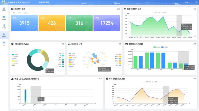
The system transmits images and videos captured by infrared cameras through the convergence of ultra-short, microwave, and carrier network transmission. Infrared cameras transmit data to the receiving base stations through ultra-short-wave transmission, so that the signals will not be blocked by forests. Infrared base stations transmit data by microwave to nearby microwave relay stations, which transmit the data to nearby management and protection stations, eliminating the need for cabling in the mountains. Management and protection stations can also use the operator network for the digital platform to transmit the data to the central equipment room of the management bureau, thereby preventing repeated construction.
Through convergence transmission technology, the images and videos taken by infrared cameras can be transmitted to the central equipment room in real time, significantly saving human resources. (In the past, workers needed to collect pictures regularly.) The system can use the AI algorithm from the digital platform to identify and classify the collected images, and automatically form a basic database.
Data middle-end:
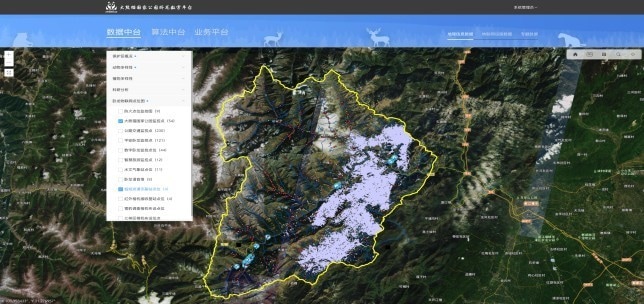
All GIS data, real-time IoT data, and thematic data in Wolong are centralized to the middle-end through data middle-end technologies. The middle-end provides an overview, animal and plant distribution, and IoT point distribution map to external parties. It also contains infrared cameras, monitoring, environment, and water environment data. Thematic data includes project images, landscape images, and video panoramas.
Smart ecotourism system:
The system uses advanced technologies such as cloud computing, big data, IoT, and mobile Internet to form a comprehensive management and control platform that integrates smart management, marketing, services, and experience.
This platform is built using the visitor management system, virtual education hall system, existing information networks, tourism big data, and global tourism distribution systems. Tourists can book and buy tickets through the mini-program, obtain descriptions online, view the distribution of education stations, and report information on animals found. The system provides tourists with an interactive recreational experience and encourages the public to actively participate in ecological protection.
Comprehensive management of resources on one map:
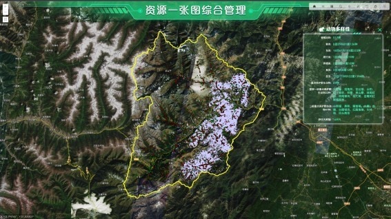
Communications technologies combining optical fiber transmission, microwave transmission, ultra-short-wave transmission, and BeiDou positioning are used to connect all offices and protection stations on one network. After sorting the basic resource data of the protected area, the system forms thematic data layers, including a map of forest resources, data of forest resources through China's second land survey, distribution areas of rare animals and plants, and the distribution of main interference factors. After the basic information is imported to the system, layers can be overlaid to compare and analyze the distribution of different animals and plants. In addition, management personnel can extract and convert the data to directly view the status of the park and make decisions supported by the data.
Case study Qilian Mountain Pilot National Park (in Qinghai)
Representative protected species:
Snow leopard
Applicable scenarios:
Meteorological monitoring, wildlife monitoring, vegetation monitoring, water environment monitoring, glacier monitoring, intelligent patrol, fire protection, disaster warnings, emergency command and dispatch, comprehensive smart management, and public education service management
Technologies:
RS, GPS, GIS, big data analysis, cloud computing, AI, automatic sensing, machine vision, wired and wireless converged networks, and IoT
Main equipment:
Infrared cameras, checkpoint cameras, high-level PTZ, drones, hand-held patrol terminals, underground optical fiber sensors, video surveillance devices, signal detection devices, wireless network base stations, remote sensing/communications satellites, cloud data center, a mobile monitoring platform, and an integrated management platform
The Qilian Mountain Pilot National Park has identified and optimized the distribution of various ecological monitoring network branches to establish an integrated monitoring system that supports intelligent sensing. 520 kilometers of optical cables were laid in the pilot, along with an integrated 300 Mbit/s communications network for radio and television broadcasting and the BeiDou Navigation Satellite System that is used in conjunction with other communications tools. Together, they enable network communications and transmission in some parts of the pilot.
In addition, 108 high-order video cloud platforms, 227 wildlife cameras, and more than 1,500 infrared cameras have been deployed to support real-time online monitoring across 8,000 km2 of the park. A big data management platform has also been established for the pilot, which allows for various types of common basic data, community data, ecological resource data, IoT monitoring data, and public service data to be integrated. All ecological information gathered can be displayed on the big data management platform, allowing massive amounts of data from different sources to be managed in a unified manner. This big data management platform can also display service data covering more than 50 topics, enriching the application scenarios for big data in national parks. With technologies like microservices, big data analysis engines, ecological predictions, ecological impact assessments, and intelligent analysis of remote sensing images, this platform serves as an intelligent brain that can fully unlock the value of data for ecological preservation; inform the formulation, implementation, and promotion of ecological policies; and support subsequent policy management.
Major smart scenarios:
Global monitoring system:
Thanks to three-dimensional geographic information system (GIS) technologies, remote sensing images with high spatial resolution are used to create a comprehensive resource base map for ecological monitoring. Based on the base map, continuous, long-time series image data captured by the space-air remote sensing and monitoring system can be vividly and clearly displayed, highlighting data like forest land type and distribution, land use change, and interference from human activities. This has allowed park staff to spot potential incidents and directly intervene based on the map. Through automated cruise flights in key areas and key scenes, users can get a clear picture of key ecosystem types within the park along set patrol tracks on a 3D map and view the distribution and activity of different animals. Users can also analyze how animal activities affect and are impacted by their surrounding habitats through a 3D electronic sand table, which provides data necessary for scientific research and analysis.
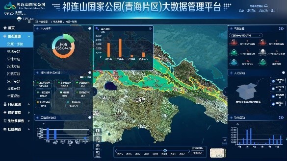
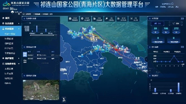
Global monitoring system
Intelligent patrol system:
This system, which has both a web app and a mobile app, uses a three-layer architecture for edge, cloud, and device resources. Thanks to this system, related authority can be delegated to ground-level management and protection stations, enabling rapid service provision. In addition, the BeiDou-enabled positioning services can support investigation into and patrols of natural resources such as forests, wetlands, grasslands, animals, and plants. This allows management and protection stations to better supervise rangers' patrols in the park and observe resource patrols in real time. Being able to talk with rangers via voice and video means that management and protection stations can better understand rangers' actual work and handle patrol incidents in a timely manner. The intelligent patrol system supports safety management, assignment distribution, and online monitoring of rangers. It also ensures the safety of resources in the pilot, and improves patrol supervision.
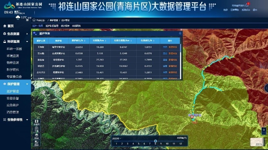
Intelligent patrol system
Ecological scientific research management system:
This system brings together an intelligent wildlife identification system, a scientific research sharing platform, and several other subsystems. Front-end monitoring devices are used to continuously capture pictures of animals, record short videos, and send these recordings back to the information platform. The intelligent wildlife identification system then intelligently analyzes the bodies, faces, and movements of the wildlife in the recordings, and identifies their species, quantity, and activity area. With an animal and plant sample database and a thematic map for dynamic distribution, the intelligent wildlife identification system can then analyze species population and habitat trends, and reveal how these trends affect and are affected by the environment, meteorology, human activities, biodiversity, and other factors. This creates detailed data that can be used to further analyze trends, assess the value of a biodiverse ecosystem, and intelligently support ecosystem management and scientific research. The scientific research sharing platform supports data integration, sample collection, intelligent analysis, and capability sharing. With an expert information database, this platform allows experts in various fields, universities/colleges, and research institutes to communicate with each other and conduct research on protected areas.
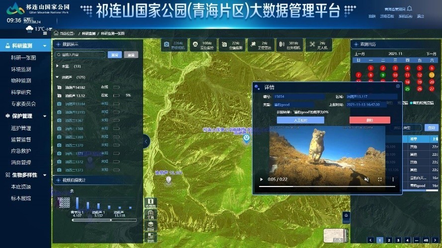
Ecological scientific research management
Ecological assessment management system:
This pilot utilizes professional algorithms and a multi-dimensional approach to ecosystem assessment and evaluation by using the data dynamically sensed and collected by the front-end space-air-ground integrated monitoring system. This represents a shift from qualitative to quantitative assessments when it comes to ecological quality, management and protection capabilities, and disaster warning. This also makes it possible to assess the ecological value and trend of each region, species, and ecosystem in the park, and provide early warnings and forecasts for the park administrator.
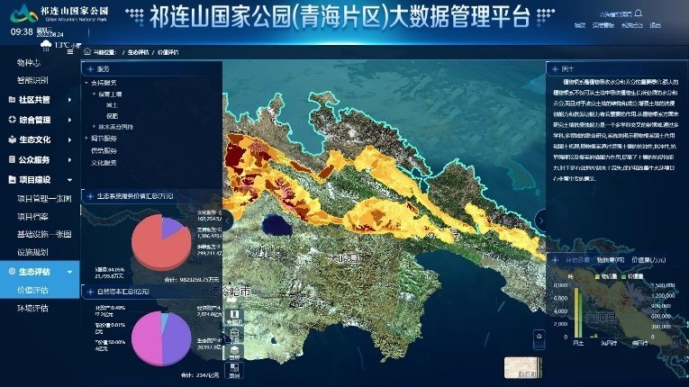
Ecological assessment management system
Case Studies on Management of Smart Nature Reserves
Nature reserves serve a different purpose than national parks, which means that the ways they are managed are also different. Nature reserves mainly focus on monitoring dynamic changes of protected species, and designing and carrying out related protection activities. Building smart nature reserves is about infusing intelligence into protection activities, research, awareness programs, and nature experiences for protected species.
Case study Songshan National Nature Reserve, Beijing1 2
Representative protected species:
Natural secondary Pinus tabulaeformis forests, leopards, golden eagles, imperial eagles, black storks, and other rare and endangered animals.
Applicable scenarios:
Resource management and protection, ecological monitoring, fire prevention monitoring, and land use management.
Technologies:
Remote sensing (RS), global positioning system (GPS), and GIS, big data analytics, cloud computing, artificial intelligence (AI), automatic sensing, machine vision, and wired and wireless converged networks.
Main equipment:
Artificial nests, infrared cameras, drones, handheld patrol devices, road checkpoint monitoring devices, ultra-short-wave communications base stations, base stations that can receive signals from infrared cameras, and remote sensing/communications satellites.
The Songshan National Nature Reserve in Beijing has used diverse monitoring data and space-air-ground technologies to establish an integrated information management platform that supports functions like resource management and protection, ecological monitoring, fire prevention and monitoring, and land use management. These technologies include video surveillance, early warnings, and drone monitoring in space, satellite navigation and intelligent wild patrol technologies in the air, as well as video surveillance base stations, handheld patrol devices, wildlife monitoring instruments, and other technologies on the ground. This integrated information platform makes space-air-ground integrated supervision possible, as it allows information about animal and plant resources, management personnel, and management facilities to flow freely and to be used and analyzed easily. The purpose of the platform is to enable intelligent monitoring and management of biodiversity in the nature reserve.
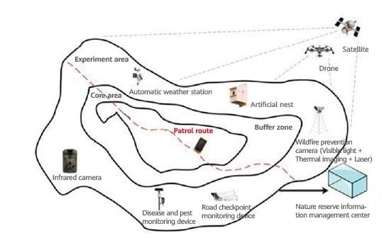
Major smart scenarios
Integrated smart nature reserve platform:
The platform consists of a background resource database and a comprehensive management database. Supported by technologies like big data analytics, unified identity authentication, cloud computing, and cloud services, this integrated platform allows resource information that has been dynamically captured by monitoring facilities to flow intelligently. The monitoring facilities include those used to monitor ecosystems, water quality, phenology, bird nests, and forest sample plots in the nature reserve. In addition, this platform has 12 information modules: resource background, patrol monitoring, infrared cameras, video surveillance, environmental monitoring, quarantine pests, sample management, bird nest monitoring, land use management, animal collars, plant phenology, and electronic boundary markers. This integrated platform supports the standardized, end-to-end management of the nature reserve.
- Beijing Municipal Forestry and Parks Bureau (Office of Beijing Greening Commission) http://yllhj.beijing.gov.cn/ztxx/lhysh/st/202009/t20200924_2091388.shtml
- Beijing Municipal Research Institute of Eco-Environmental Protection https://www.cee.cn/detail.php?myid=1458


Recommendations for Building Smart Protected Areas
Roadmap
Digitalization has already begun in many protected areas. However, the progression of these efforts and the value of the resources and wild environments they protect vary from location to location. This means the solutions needed to go smart also differ from location to location. First, smart protected areas are more than just a combination of different smart scenarios. They require top-level designs and a unified solution architecture, under which the characteristics, operation management status, and objectives of the protected areas are considered. This is crucial for preventing repeated investment and information silos. Protected areas do not become smart overnight. Instead, their construction is an iterative process. The standardized digital architecture serves as an underlying platform to support iterative updates of technologies and planning for smart protected areas and gradually streamline vertical application scenarios. This better supports the construction and management of smart protected areas.
1. Promoting Unified Data Standards to Create One Map for Natural Resources
To help protected areas go smart, we need to establish more unified data standards to facilitate data aggregation and integration and eliminate data silos. This is a key step that will allow protected areas to map out their natural resources in a unified manner. By aggregating data from different systems, protected areas can build their own converged and shared information platforms that offer the data needed to create maps of their natural resources. There are six areas in a natural resource investigation and monitoring system that need to be unified: overall design and work planning; system and mechanism construction; setting standards and indicators; organization, implementation and quality control; unified data result management and application; and information release and shared services. Against this background, protected areas must consider a number of factors when planning data foundation consolidation and data result management to match their unique needs:
Sensing system standardization:
On the business side, protected areas can quantitatively assess ecosystem types and their value, and guide efforts to set unified technological standards for ecological factor selection, sample data selection, sample plot selection, and ecological factor collection. This will ensure standards reflect actual ecological characteristics and make different types of monitoring data comparable.
Unified data standards:
On the data side, protected areas can establish a unified standard information system based on the monitoring indicators that come from the business side. The system can then standardize data formats, address problems with data integration, and maximize the value of every piece of data.
Unified data interfaces:
During the information platform planning phase, protected areas should define data interface standards and access modes, such as API protocols, IoT, and virtual private networks (VPNs), to promote data interconnection between different systems.
2. Enhancing Device and Technological Capabilities to Better Sense Ecosystems
Protected areas require enhanced ecosystem sensing to go smart. That in turn requires increasing investment in the research and development of devices and technologies, and greater efforts in deploying and maintaining these devices to ensure they better adapt to wild environments. This will lay the foundation for space-air-ground integrated monitoring networks.
Improving the performance of sensing devices:
Sensing devices, such as acoustic sensors, photosensitive sensors, and temperature sensors, need to improve data collection scope, precision, and efficiency at lower cost compared with single-function devices. In addition, efforts should be made to reduce the impact of climate, geographical environment, and time on sensors to make sensing devices more adaptable.
Making sensing devices more adaptable to the wild:
Ultra-low power designs can enable long-term standby functions and improve the battery life of devices. Waterproofing, moisture-proofing, and the ability to withstand extreme temperatures to prevent aging are also important features that will make sensing devices more reliable. Built-in wireless communications modules will also allow both primary and secondary sensing devices to support self-networking and real-time data backhaul, and adapt to wild environments that lack reliable power, O&M resources, signal, or light (or only have weak signal or light).
3. Selecting Optimal Transmission Solutions that Balance Transmission Requirements and Costs
Given the complexity and diversity of the environments technologies have to operate in, a number of factors must be considered for protected areas (e.g., cost, reliability, and security) when choosing communications technologies. Most protected areas need transmission solutions that integrate multiple technologies so that they can achieve reliable and secure data transmission in different scenarios. In addition, these solutions will need to help facilitate network maintenance and reduce limitations and interference that natural conditions and meteorological factors often place on private communications networks.
Transmission in forests and across areas with varied elevation is challenging due to high levels of interference, long distance requirements, and low levels of efficiency. Therefore, R&D investment needs to be ramped up for protected areas to break through transmission bottlenecks and achieve secure and reliable real-time data for more informed management.
4. Developing More Applications for Ecosystem Scenarios to Support More Intelligent Management
Big data can be used to improve the management of protected areas. If data assets for protected areas are shared and developed with other stakeholders, large amounts of data can be leveraged to develop a system for performance evaluation, protection and service efficacy evaluation indicators, and reporting. This data can inform decision making during operations management. To make that happen, more investment is required to develop applications for main scenarios such as ecological conservation and restoration, scientific research monitoring, and resource management.
Improving the ability to analyze existing smart scenarios:
Currently, protected areas are mainly focused on developing applications for main scenarios such as scientific research monitoring and resource management. In the future, they will need to collect even more data and promote machine learning and model training using a large number of basic data samples, so as to improve AI identification, computing power, sensitivity, and accuracy. Ultimately, this will allow the management platforms of smart protected areas to support more intelligent management.
Developing other important smart scenarios:
Protected areas should also develop diverse smart application scenarios step by step and create a unified management platform by streamlining existing scenarios. This platform may include an ecological law enforcement management system, smart recreation system, and smart community governance system, which can make the management of protected areas more efficient.
5. Making Full Use of Data to Create Shared Platforms
More value can be extracted from data generated by protected areas by strengthening ties with ecosystem partners, further exploring potential market demands, and developing diversified digital products. For example, monitoring information that has been collected and analyzed can be used to develop interactive applications for scenarios like ecological education and nature experiences. This can help create an ecological industry model that supports and draws from both traditional culture and green lifestyles. With data from protected area smart platforms, private enterprises with advantages in remote sensing technologies can develop applications to prevent poaching, manage human-animal conflicts, and support cultural and ecological education in local communities. These new applications would in turn attract more users from government and the general public, creating even more economic value from the data.
6. Improving Public Sharing Mechanisms to Benefit Everyone
The construction of a smart protected area requires the participation of the general public and must also consider the needs of different stakeholders, including the media, community residents, and the general public. Protected areas going smart need to deliver better experiences to stakeholders in multiple scenarios, provide more non-profit public services to the general public, and make full use of ecological experience resources. This will make protected areas places where communities can build, govern, and share value together. By building and improving information dissemination and exchange mechanisms, protected areas can vividly showcase the value of protecting nature to the public, so that the public can get closer to, experience, and understand nature better.
Building an Ecosystem for Smart Protected Areas
Protected areas must go smart to ensure effective protection, to share achievements with the public, and to be sustainable for generations to come. Going smart involves many application scenarios, which require buy-in from protected area administrators and the engagement of experts in biodiversity, species conservation and restoration, ecological conservation, and more. These experts can help clarify where protected areas need to go smart, and provide specialist guidance on the sources for data collection and data analysis methods.
In addition, these scenarios require R&D investment to integrate multiple types of infrastructure and technologies. Different stakeholders need to make full use of their resources and professional advantages to create an ecosystem for smart protected areas. While pursuing ongoing innovation and hands-on practice, protected areas must also work to interconnect and integrate different types of data, give different professional operation service ecosystems access to such data, and develop a shared and symbiotic ecological cooperation system. For example, protected areas can visualize information about natural spaces, including information about ecosystem types, ecological value, ecological restoration efforts, and ecological disasters, and create a mechanism for sharing scientific research data after enough background data is gathered and integrated. Research teams could combine informatization and research efforts by sharing basic monitoring data for similar regions, and streamline and share their findings horizontally. At the management and operations level, protected areas need management mechanisms that can be clearly displayed with digital technologies, which can inform the management of the protected area management bureau. As for franchised business operations, protected areas can provide ecological information services to the public, employ intelligent means to expand industrialization scenarios and business models using an Internet mindset, and introduce social capital to promote mechanisms for cooperation with local communities.
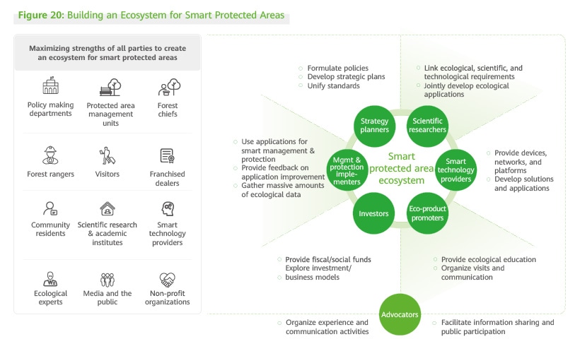
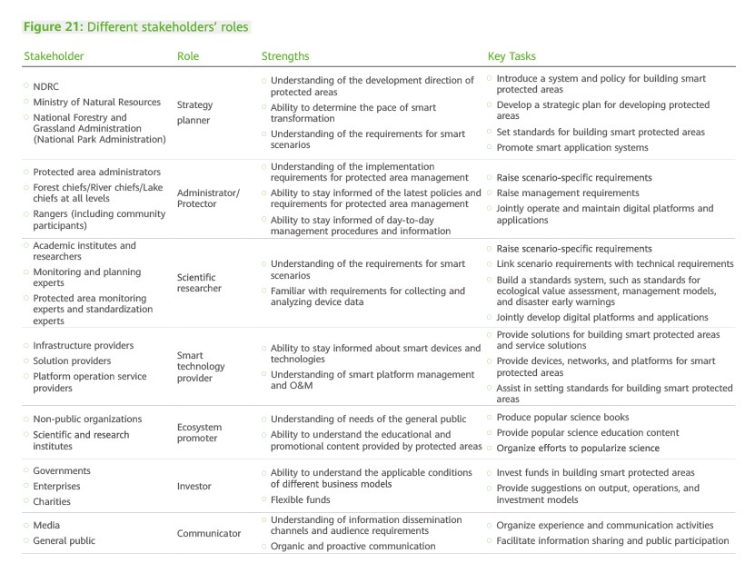
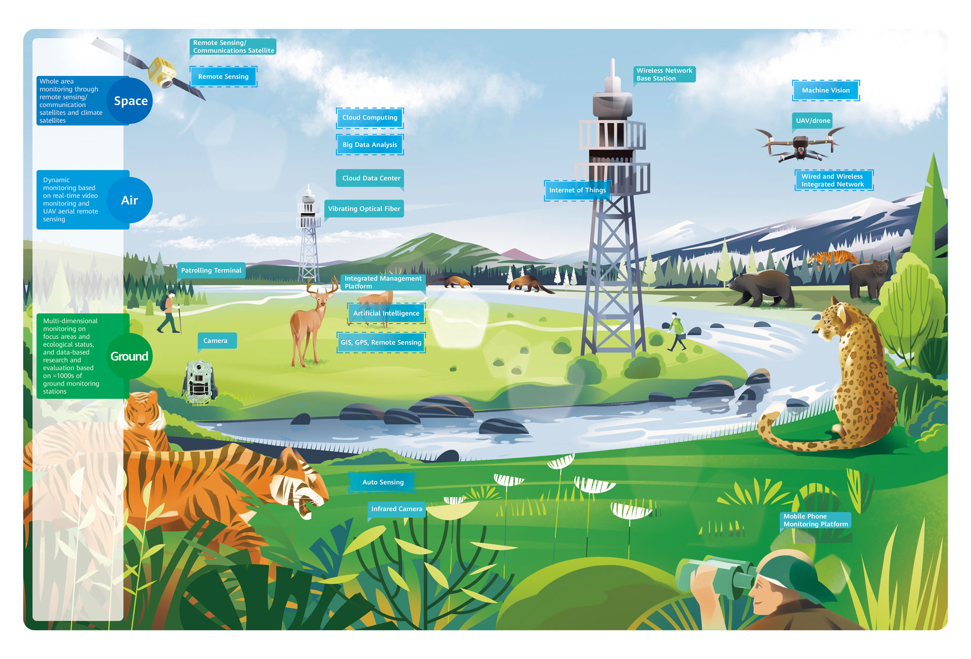
Published in
June 2023
Copyright Notice
The Ecology and Nature Conservation Institute of Chinese Academy of Forestry, the China Country Office of The International Union for Conservation of Nature (IUCN), and Huawei Technologies Co., Ltd. own the copyright for this White Paper. Other parties who reprint, excerpt, or use part or all of this White Paper in any way shall indicate the source. Those who violate this stipulation need to bear relevant legal liabilities.
